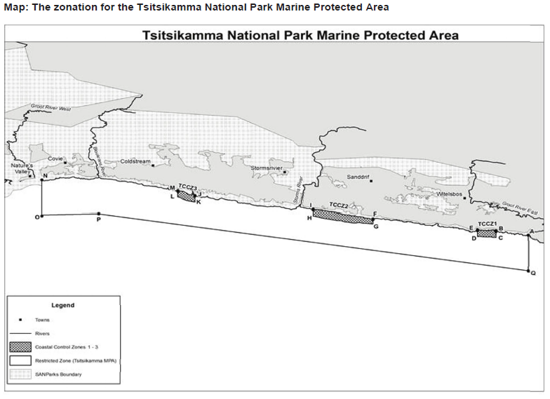
Northern boundary is the high-water mark between Die Punt, Nature’s Valley, at S33°59.0′ E023°34.561′ (west), and the right bank of the Grootrivier at S34°03.6′, E024°11.665, (east)
Eastern boundary is a line from the right bank of the Grootrivier at S34°03.6′, E024°11.665, running due south to a point three nautical miles offshore at S34°06.6′, E024°11.665
Southern boundary is a straight line from S34°06.6′, E024°11.665, approximately parallel to the shore, to a point three nautical miles from the high-water mark at S34°01.817′, E023°38.857E measured along a line running due south from the right bank of the mouth of the Bloukrans River, and then due north to a point 0.5 nautical miles from the high-water mark at S33°59.317′, E023°38.857′, and then along a straight line roughly parallel to the shoreline to a point at S33°59.5′, E023°34.561′ due south of Die Punt, Nature’s Valley.
The western boundary is a line from the high-water mark at Die Punt, Natures Valley, at S33°59.0′ E023°34.561′ due south to a point about 0.5 nautical miles offshore at S33°59.5′, E023°34.561′ The northern boundary of the MPA is the southern boundary of the